Click here for detailed map
Introduction
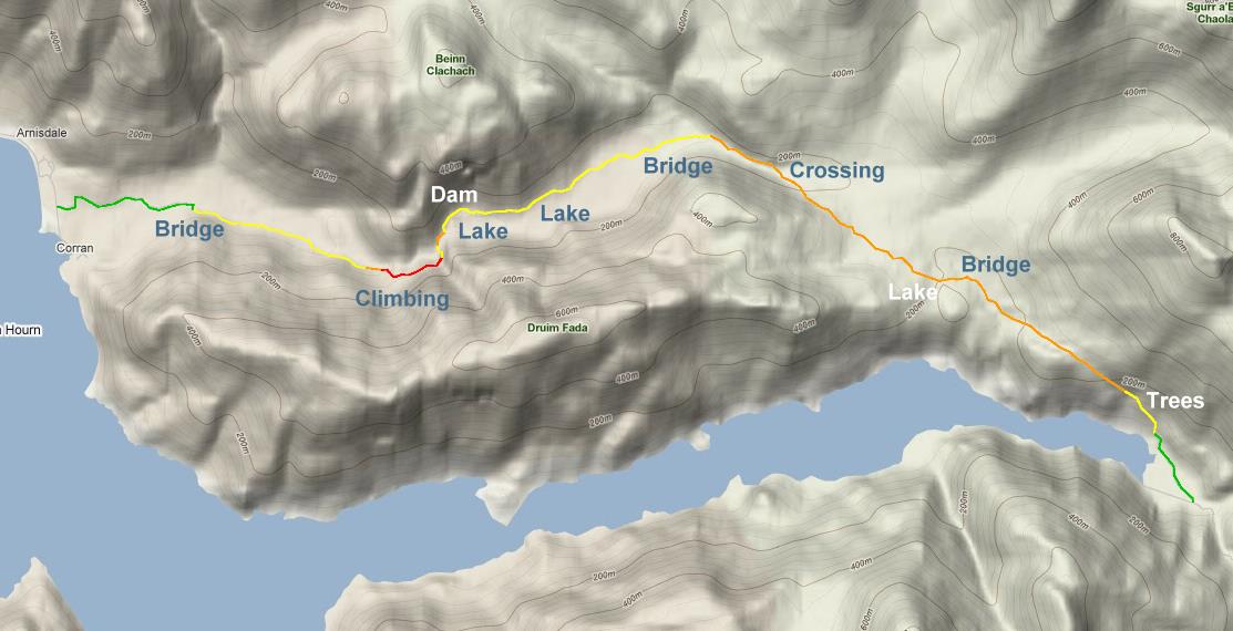
If you're touring Scotland on a bike and want to go off road, then going through Glen Arnisdale looks like one of the easiest routes to take. Mind you, going off road in Scotland never is easy. On the internet I found a story of someone who did this same route, but in the other direction (which I think is easier). He described the route as not too bad. And the route is a proposed on the Sustrans web site. All in all good reasons to have a go at it!
That day I started in Shiel Bridge towards the North. On the way is Bealach Ratagan, which is a difficult 15% climb. In Glenelg is a small shop where you can buy some goodies. Towards Arnisdale there is a good climb as well. But the view you get is worth it.
Photo's 1-4


After Arnisdale you take a left into the glen. The first bit is nice and easy gravel. The farmer that worked the land there shouted "You know about the climb?". I pretended that I did.
Over the first bridge the road gets a bit rougher. But it's good enough to keep on cycling. The nature in that part is really wonderful.
Photo's 5-8


")
Then the road goes up, and it's time to start walking! This is in a small forrest, so you can't really see where you're going. It's really steep and walking with the bike becomes difficult, and I mean really difficult! I had my hopes that after the first bend things would get easier. But that didn't happen. After the bend the road just went up more and more. I tried to climb up there with the bike, but it was just impossible no matter how hard I tried. The only thing for me left to do was to take the stuff of the bike. In the mean time lots of midges started to attack me and I had to put on some anti insect stuff.
I was able to climb up the hill with the loose panniers. But even that wasn't easy. The loose rocks made it hard for me to find any grip and I was sliding all over the place. Going up and down 3 times I managed to get everything up the next bend. After this 2nd bend the road was still very steep, so I carried my stuff a little further up before putting it all on my bike again. This all did provide for an excellent view all the way to the Isle of Skye.
Photo's 9-16


After the climb there is a steep decent towards the 2nd bridge. But thanks to my wide handlebar I had no problems here staying on the bike.
Towards the dam there is a small stretch with rough rock where you have to walk. There is a small but pretty waterfall. Taking that picture wasn't easy with all the pedestrians walking there. Ok, it would be the only person I'd see for the whole stretch. She was all knowing telling me that walking was easier. I really couldn't disagree.
After the dam things are pretty flat and cycling is not too difficult. The 3rd bridge crosses a river comming from the east. After that you end up on a small plain including a junction with a road going to the east towards I don't know. There's also an abandoned house.
Photo's 17-21


")
Following the river the road gets worse. Eventually I ran out of road and it was time to cross the river. There is no warning or sign that tells you where to cross it. I just had to pick a spot. At places the river is a meter deep, so crossing it wasn't easy. Manoeuvring very careful from rock to rock I managed to do it without getting my feet and the bike wet.
After the crossing I picked up the road again that went up a hill. The surface was bad so I had to walk. On the hill again I was left with a great view.
Note, the big electricity pylon on photo 17. That is the same pylon as on photo 21 in the middle of the zigzags of the river.
Photo's 22-27


")


Then the road gets more technical. It goes up and down with rocky patches and small streams. Cycling can still be done, but not all of the time. The streams are mostly small enough to be crossed cycling. Tire marks in the mud are a sign that mountain biking is being done here. A nice lake seems to flow right into the Loch, which is close by. The road gets rougher and more walking has to be done. Going down I had to cross the last bridge . . . after which you have to go up again. The path is very small in places, so you have to look carefully where it goes. At this time I mostly had to walk.
Just before the end, the road goes down . . . a lot! Some of it was so steep, I had to walk down. When I reached some woods there is a gate you have to go through. Going down this forrest is technical as well. After which you end up at a farm and at the end of this route!
At 8 o'clock in the evening I reached the campsite at Invergarry.
Timetable
13:50 The start of Glen Arnisdale
14:00 1st bridge
15:00 2nd bridge
15:45 junction and abandoned house
16:10 river crossing
16:55 4th bridge
17:40 Kinloch Hourn
Equipment
Bike: Van Nicholas Pioneer (titanium)
Tires: 26 inch Schwalbe Marathon 47mm
Panniers: Vaude Aqua front panniers, back panniers and handlebar bag
Saddle: Brooks B17 Titanium (springs would have been nicer)
Pedals: Shimano XTR
Shoes: Shimano Touring shoes
Socks: SealzSkin
Links
Broadford – Glen Arnisdale (Peter M)
Glen Arnisdale – Fort Augustus (Peter M)
Back